There are 246 miles of maintained trails and many miles of unmaintained ‘boot paths’ in Mount Rainier National Park. These trails offer exceptional opportunities to experience wildflowers for the day hiker, the primary audience of this site.
Day Hiking Guide Books
There are several day hiking guide books to choose from that are available at outdoor stores as well as the visitor centers and gift shops at the park. The 2nd edition of Mountaineers Books “Day Hiking, Mount Rainier”, 2018, by Tami Asars is certainly a worthy consideration. It includes eighty hikes that are within the park and the surrounding areas of Crystal Mountain as well as Cayuse and Chinook Passes. Tami has extensive experience in Mount Rainier and we can be assured that all these hikes have been “boot tested.”
Another book used as a reference here is Ron Judd’s 4th edition of “Day Hike! Mount Rainier”, 2019. A longtime favorite for many was Spring and Manning’s “50 Hikes in Mount Rainier” published by The Mountaineers. After its 4th edition it’s been replaced by subsequent guides, such as Asars. A great collector’s item nevertheless.
Online Hiking Resources
Hikers in the Northwest have come to rely heavily on the hiking guides and trip reports provided by the Washington Trails Association, www.wta.org. While not advocating that these resources replace the need for guide books and physical maps, WTA guides/reports can provide up-to-date information and perhaps some insights not found elsewhere. WTA may also provide alternate routes. For example, the Mountaineers guide (Asars) uses what WTA calls the “classic” approach to Grand Park (via Sunrise). WTA suggests trying the “backdoor” approach via Lake Eleanor which is the route used on this site for the Grand Park Wildflower Map/Guide.
Wildflower Hike Map/Guide
Virtually all the hikes included in Mount Rainier day hiking guides present wildflower viewing opportunities although they aren’t specific about them. The wildflower hikes feature of this site attempts to complement these guides with wildflower information in the form of a map/guide for those hikes that truly represent exceptional opportunities (currently thirteen). It is not the intention here to replace the guidebooks and detailed maps which are necessary resources for hiking in the park.
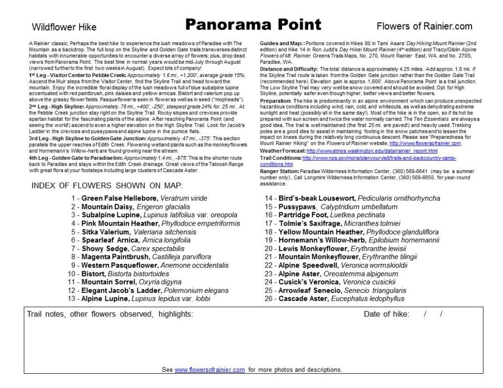
A wildflower hike can be a difficult thing to describe! According to the Park Service web site there are 890 species of vascular plants in the Park so naturally what is shown for each hike is merely a sampling of what can be experienced. The attempt here is to provide an easy to use simple two page guide for each hike with a map and narrative guide and flower index which can be printed back-to-back. The route of the hikes are usually divided into three or more sections, or “legs”, since many of Rainier’s great flower hikes transcend elevational zones and encompasses multiple habitats, thus the species composition will vary considerably within the hike. The narrative briefly describes each leg giving distance and elevation information and flower highlights. The flower index provides common and scientific names for the flowers shown on the map.
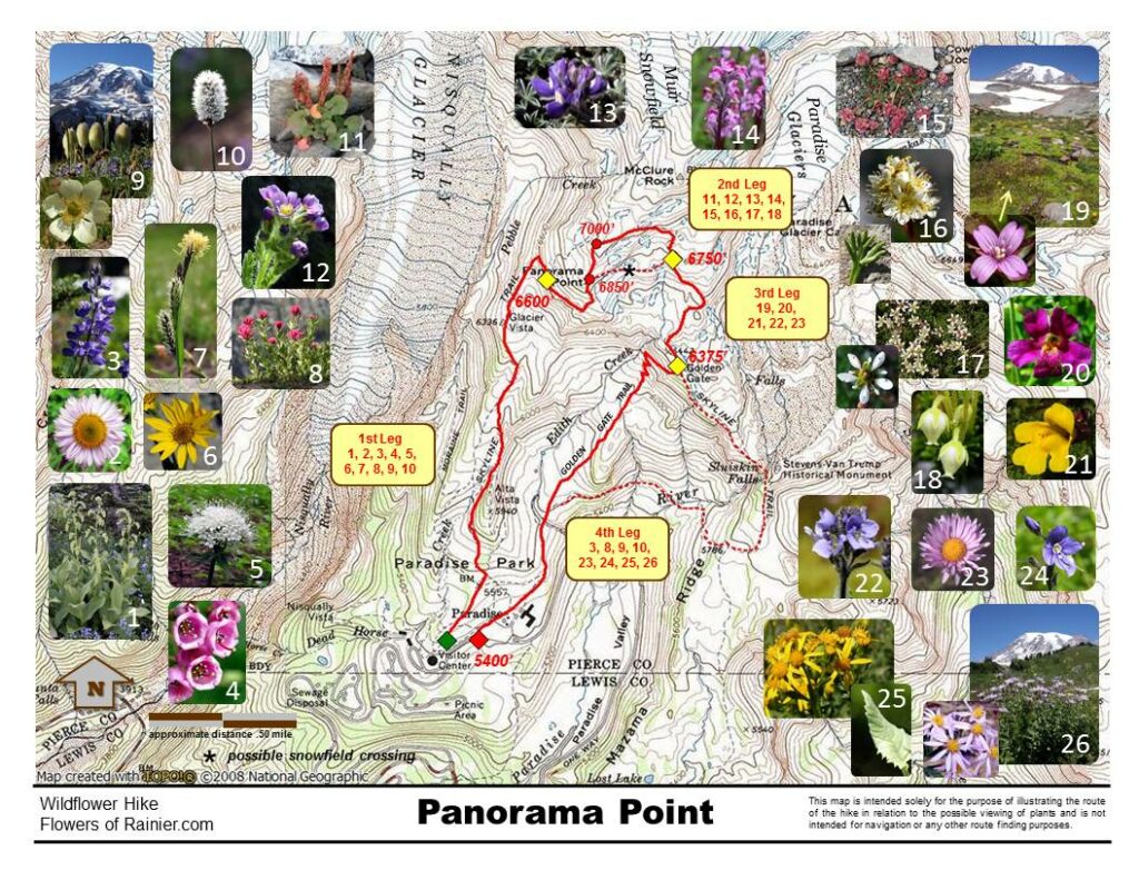
Special thanks to National Geographic TOPO! for permission through an extended user license agreement to use maps generated from TOPO! Series for Washington. Wildflower photo inserts are added to the map base along with trail routes and other information which obscures some of the map detail. Specific distance, grade and other information for each leg is provided in the narrative guide. These maps are intended solely for the purpose of illustrating the route of hikes in relation to the possible viewing of plants and are not intended for navigation or any other route finding purposes.
Users of the maps and wildflower guides must assume full responsibility for their own actions and safety. The maps and guides are not routinely updated to reflect changes that may have occurred in the field, nor can any such changes be anticipated. Therefore the onus is on the user to check conditions using the references cited in the Hiking Preparedness article before setting out. Use of a respected published guidebook is highly recommended as well as obtaining the best detailed maps. The wildflower maps are not intended to replace other maps such as Green Trail Maps, USGS Quad maps, or other maps produced with National Geographic TOPO!.
Importance of Staying on the Trails
With very few exceptions the flowers presented in the site’s portfolio and those highlighted on the wildflower map/guides can be viewed directly from a maintained trail and there is little need to go off trail to observe or photograph Rainier’s flowers. Careful judgment must be exercised if off trail for much of the park is a fragile environment. Even in the forest zone, where meandering may appear do the least damage, wet areas can be easily affected; and don’t forget about the orchids, several endangered species reside there.
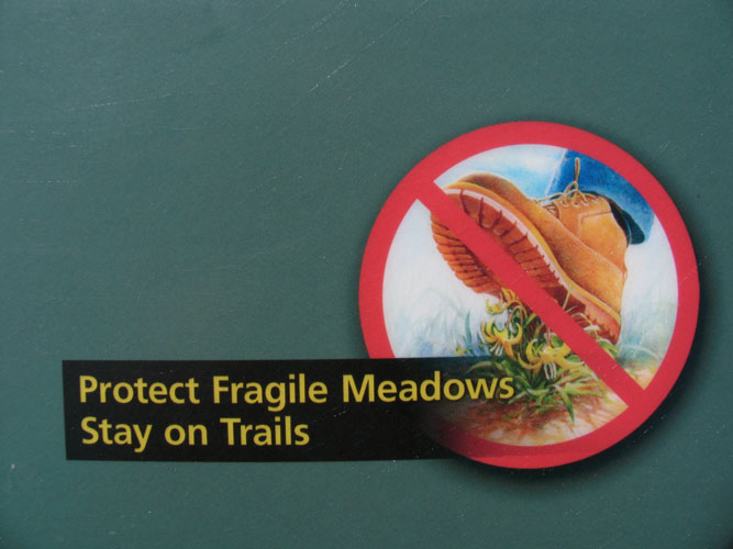
An old adage warns plants grow by the inch and die by the foot. Please don’t make it your foot!
Wildflower Hiking Seasons
All of the wildflower hikes presented here, with the exception of Green Lake (early), are predominantly in the subalpine and alpine zones of the park, meaning they are in elevation ranges above approximately 5,000’. Please see Wildflower Distribution in Mount Rainier National Park for a detailed discussion of elevational zones.
We should not view hiking in the park as having only one season. Snowfall in the park is significant and has even set some historic records. Peak wildflower blooming is highly dependent on the extent of the winter’s snowpack, springtime weather and timing of snowmelt. Some of the best high country wildflower areas of the park may not even be accessible until well into the summer. For example, it is not unusual for the Sunrise Road and Mowich Lake Road to remain closed until after the 4th of July. However, there are many wildflower opportunities for those who want to get up there early. Always check current road and trail conditions using the links in “Preparedness for Mount Rainier Hiking.”
The wildflower season can be thought of as having three phases:
Phase 1 – May and June
With much of the high country still snowed in wildflower enthusiasts need to explore the wonders of the forest zone below the timberline (see “wildflower distribution”). Nearly 100 of the 248 species presented on this site reside in the forest zone so there is plenty to see. Enjoy the old growth forests of Rainier and surroundings at a time when the crowds are at their fewest! Here’s a sampling of some good areas with early wildflower viewing opportunities.
In the far northwest corner of the park are several areas that are reached using SR 165 which goes through Wilkerson and Carbonado. Going passed the “new” visitor center along the Carbon River you reach the Carbon River rain forest and the old Carbon River road that is now closed to vehicular traffic (good bike route though) which will take you to the Green Lake trailhead (described here as Green Lake (early)). Also consider hiking up the Carbon River from Ipsut Creek camp to the suspension bridge. Paul Peak (28 in Asars) is a good early choice with a reverse profile (downhill first!) that takes you to the North Mowich River. The trailhead is off the Mowich Lake Road but before the section that is closed for the winter.
Entering the park at the Nisqually entrance the southwest area has several early possibilities. Rampart Ridge out of Longmire, as well as the short nature trails near Longmire, are worthwhile and may even be better in the spring than the summer. See Asars for details. A surprise for wildflower enthusiasts is the Westside Road a mile or so on either side of the road closure at Fish Creek. The sheer walls of Mount Wow loom on the west (look for goats) and the turbulent Tahoma Creek on the east.
Access to the southeast portion of the park is snowmelt dependent. A delayed opening of Cayuse Pass will prohibit access from the north via SR 410 and SR 123. At Deer Creek, south of the tunnel, is the Owyhigh Lakes (from the east) trailhead which is also the trailhead for the Eastside Trail which parallels Chinook Creek and the Ohanapecosh River. Explore sections of this great riparian area with its numerous waterfalls, or hike it one way down to the Stevens Canyon entrance (see Asars hike 42). Closer to Ohanapecosh camp don’t miss the Silver Falls Loop Trail (46 in Asars), also probably better in the spring; you might even spot the elusive fairy slipper (Calypso bulbosa).
The northeast area is a bit more challenging and most early hiking opportunities would be outside the park. In the park if it’s a light snow year the trail to Lower Crystal Lake may be hikeable in June. See the Asars guide for hikes in the Greenwater area. Favorites outside the park that may be doable in June include Kelly Butte and Noble Knob.
Phase 2 – July (mid-July) and August
Hopefully by no later than mid-July the mountain should be open for business and all the wildflower hikes presented here should be accessible. However, it can’t be emphasized enough to check the road and trail conditions by going to https://www.nps.gov/mora/planyourvisit/trails-and-backcountry-camp-conditions.htm.
Several hikes will continue to have snow over sections of their trails well into the summer and those that are on steep side hills are particularly hazardous. Examples include both the south and north sides of Burroughs Mountain, the Skyline Trail east of Panorama Point and possibly the Panhandle Gap portion of Summerland.
Our wildflower experience can also be affected by another weather related phenomenon. While we’ve worried about snow and spring rain the summer can often bring very dry conditions and intense hot spells. What started out looking like a great summer for wildflower hiking becomes disappointing; what are normally lush subalpine meadows become just grassy looking slopes. As a result mid-August may in fact be too late to experience peak wildflower blooming. Since Mount Rainier has become such a world renown wildflower destination, the Park Service is providing more and better information on the status of blooming in the park. It is hoped this will continue. Go to https://www.nps.gov/mora/planyourvisit/wildflower-status.htm.
Phase 3 – Late August and September
By mid-August we can expect that blooming is complete for most of the flowers of the subalpine zone, their seeds are set and distribution has begun (go to Western Pasqueflower, Anemone occidentalis, to see the full life cycle of one of the park’s more interesting plants). It is not to say that in some years with heavy snowfall, a late spring, and cool summer that much blooming can continue through the month.
However, the flora experienced when hiking in September can be interesting. Some of the very high areas, i.e. above 7,000’ elevation, are accessible and maybe snow free for the first time; for example, Panhandle Gap above Summerland, Third (Outer) Burroughs Mountain, Paradise Glacier. One spectacular plant doesn’t even reach full bloom until mid-August/September; Mountain Bog Gentian (Gentiana calycosa) has a remarkable iridescent violet tubular flower awaiting those who hike when others have chalked it up for another year. Additionally, Rainier will begin showing its fall colors and it’ll be time for berry season.